A new article has been published at prMac.
Ocean Levels 1.0 for iOS - Displays Projected Ocean Level Increases - Published on 09/04/14
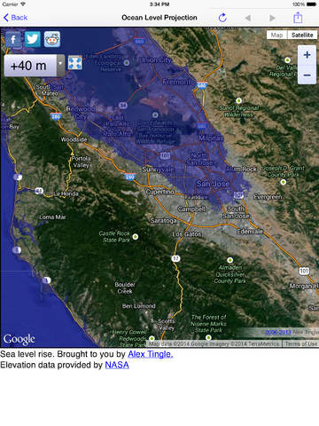
Predictive-first developer Ken Tidwell today introduces Ocean Levels 1.0 for iOS, his new location-aware mobile app. Ocean Levels displays projected ocean level increases using NASA Shuttle Radar Tomography Data to show what various changes in water level. Users can easily see the effects of increased flood levels relative to their current location using different flood depths, whether from ocean-level rise, storm surge, tsunami or perhaps even an open-ocean asteroid impact.
Portland, Oregon - Predictive-first developer Ken Tidwell is proud to announce the release of Ocean Levels 1.0, his new weather app for iOS devices. Have you ever wondered what higher water levels from tsunamis, hurricanes and monsoons might look like where you or your loved ones are right now? Are you planning to relocate your home or start a business near the ocean? Are you interested to see if your route to higher ground in case of higher water and severe weather might work as planned?
'Ocean Levels' is a location aware mobile app allowing you to see the projected effects of increased flood levels relative to your current location using different flood depths, whether from ocean-level rise, storm surge, tsunami or perhaps even an open-ocean asteroid impact.
"While there are other projected flood maps from various agencies and institutions, none of them yet attempt to plot your live location on any of their maps," stated Ken Tidwell of Min-U Guides. "We are proud to be the only ones to supply you with the most modern flood mapping data representation available."
You can choose to view your current location with various pre-selected water depths (in meters), or select from shortcuts to view global regions as desired. All maps are fully navigable including touch, pinch/zoom, double-tap/zoom, tap-hold/pan, flick/pan to move around quickly and easily. Choose views from 'Map' (with or without terrain) or 'Satellite' (with or without labels). You can also share your current (or selected at will) location via email.
* The projections utilize NASA 'Shuttle Radar Tomography Mission' (SRTM) data to plot the different water level depths
* Ocean Levels is currently localized in English and Simplified & Traditional Chinese with several new languages coming soon
* Airplay output to larger displays is supported
* Privacy - Please note that no user data is captured or stored and is only used to plot your location on the rendered maps
* All app controls and features are explained via the included 'Info' documentation
* Projections are not made for bodies of fresh water that are not connected to the sea
"We will be attending sea-level and predictive-first related conferences in the US during 2014 and 2015 and look forward to engaging with others to discuss and help address this very interesting topic," said Ken. "We will also continue to expand localization with additional languages being planned over the next few months."
Device Requirements:
* iPhone, iPad, and iPod touch
* Requires iOS 6.1 or later
* Includes all retina devices
* Universal Application
* 13.0 MB
Pricing and Availability:
Ocean Levels 1.0 is $2.99 USD (or equivalent amount in other currencies) and available worldwide exclusively through the App Store in the Weather category. Educational pricing discounts apply for all qualified institutions.
Ocean Levels 1.0: http://www.min-uguide.com/
Purchase and Download: https://itunes.apple.com/app/ocean-levels/id903619905
Screenshot: http://a5.mzstatic.com/us/r30/Purple5/v4/7f/a8/5b/7fa85bdc-420d-77ee-1fca-f65aef0fc646/screen480x480.jpeg
App Icon: http://a4.mzstatic.com/us/r30/Purple4/v4/be/49/19/be491985-8608-4ca9-b2c3-b7f51d5c6b72/mzl.iiukubui.175x175-75.jpg
Located in beautiful Portland, Oregon, the Min-U Guides team is an independent software company founded by Ken Tidwell in February of 2009. With over three decades developing software, Ken's goal is to provide predictive-first reference materials, user guides, manuals and tutorials for a broad range of topics while leveraging Apple's unique Mac/iOS platforms. Copyright (C) 2014 Ken Tidwell. All Rights Reserved. Apple, the Apple logo, iPhone, iPod, and iPad are registered trademarks of Apple Inc. in the U.S. and/or other countries. All other trademarks may be the property of their respective owners.
*******
Link To Article: http://prmac.com/release-id-70330.htm
*******
---------------------------------------------------------------------------------
Note that you can alter delivered distributions at any time.
Login to your account on prMac to alter your channel selection, or to opt-out at any time.
No comments:
Post a Comment